
Roadmap and Itinerary
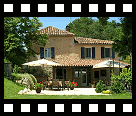
Camping La Brouquere
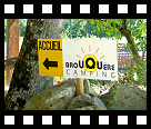
Travel directions to Camping La Brouquere
 Here you will find roadmap and itinerary information for the camping and caravan site La Brouquere.
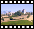
The small and tranquil adults-only campsite created around an ancient winery farmhouse is situated just outside the village of Gondrin in the heart of the Armagnac vineyards of the Gers (Gascony) in the South-West of France. This adults-only site lies roughly between Bordeaux and Toulouse.
GPS navigation coordinates
These are the GPS navigation coordinates of the campsite in different formats.
| Format: | Decimal | Degrees and minutes | Degrees, minutes and seconds |
|---|---|---|---|
| North: | lat = 43.86936 | 43° 52.162min | 43° 52min 9.696sec |
| East: | lon = 0.25844 | 0° 15.506min | 0° 15min 30.384sec |
Recommended routes to Camping La Brouquere
Recommended route from Paris to Gondrin:
- Route 1:
Parijs -> Bordeaux (A10) -> Agen (A62) -> Condom (D931) -> Mouchan -> Gondrin
This route is just a little shorter than via Limoges but there is more traffic on these motorways (especially in the summer). This route is less hilly and thus more suitable for caravans. - Route 2:
Parijs -> Limoges (A20) -> Montauban (A20) -> Agen (A62) -> Condom (D931) -> Mouchan -> Gondrin
This route is just a little longer than via Bordeaux. These motorways have less traffic and the cost for the 'peage' is a little less.
Maps and itinerary information
Itinerary information (e.g. roadmaps or travel directions) is available in different view and file formats. Click on the appropriate link to view the corresponding map.
Attention: Car Navigation Systems and the 'quickest' route...
Traveling to your favorite camping holiday destination in the Gers in France is easy enough, although you may want to pay special attention to your car navigation system during the last miles of your drive.
After leaving the main highway, several car navigation systems (e.g. TomTom, Garmin and others) suggest the presumably quickest way to the campsite. Such travel directions often take you over small and narrow country roads which are not well suited for the bigger caravans and camping cars.
Tip: follow the travel directions presented on this page to avoid stress and confusion while driving the last miles to Camping La Brouquere here in the south west of France.


News

You will also find us here
Listed in the UK Caravan Club France guide
![]()


![]() ©Camping La Brouquere - - 32330 Gondrin - France - Tel: +33 562 29 19 44
©Camping La Brouquere - - 32330 Gondrin - France - Tel: +33 562 29 19 44
Last update: 01.01.2024 - [Search this website] [Disclaimer] [Privacy] [Sitemap]


Camping La Brouquere
Rural Campsite France
Gondrin - Gers - Occitanie
RURAL CAMPSITE FRANCE
Camping in South-West France
Camping La Brouquere
Pam and Claudia Smits
F-32330 Gondrin, France
Tel: +33 562 29 19 44
Email:

What do guests think of Camping La Brouquere: